 |
| Route around Revillagegido |
6/15/11
Wow! Time is marching right along - it's already the middle of June! Climate-wise, it's definitely summertime, even when it's raining. I'm writing this at the only place in Wrangell that has internet, which is the public library. It's nice, but small and the internet is
free.
 |
| Traffic on Clarence Sound |
So we left Ketchikan on 6/11 at about 11am and worked our way out of the Tongass passage into Clarence Strait, taking a left instead of a right, this time, with a bit of a southerly wind. There was a lot of commercial traffic, barges being towed with lots of containers. I had the big jib up to help alleviate gas mileage until we hit Kasaan Bay, where the wind shut off.
 |
| Kasaan Bay - Kina Cove is on the south side |
 |
| Kina Cove - check out clear-cut |
Kasaan Bay was pretty enough, but there had been a lot of clear-cutting there and it didn’t look so pretty anymore. By now it was raining and windy. Instead of stopping at the settlement of Kasaan, where supposedly there is some Indian ruins, I kept going to Kina Cove, where we stopped. Again, it was a nice, protected cove, but it didn’t do a lot for me. We left the next day out of Kasaan Bay to start heading north on Clarence Sound. I wasn’t sure where I wanted to stop but eventually decided to a nice place called Meyers Chuck.
 |
| Meyers Chuck Public Docks |
 |
| The house with the dock is going for $230K |
 |
| Neighborhood spider web |
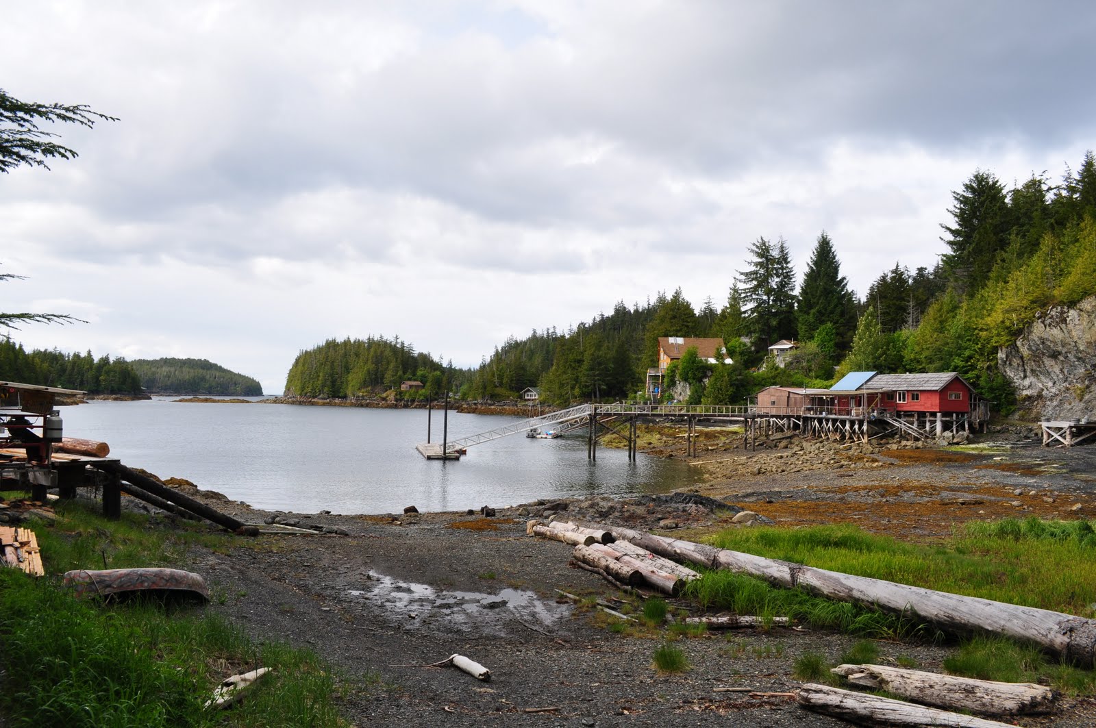
Meyers Chuck is a little settlement of about maybe 50 houses all nestled in different spots around the area. Some of them were built on big stilts and, on low tide, was perched pretty high. I came on a low tide and as soon as I tied up on a public dock, I went up the steep ramp to walk around. All of the houses are tied together with little, well-maintained paths covered in chipped bark to keep mud from building. The biggest house which was probably over 2000 sq ft had a woman working on some sort of project. She welcomed me and said to feel free walking on any path in the area. She and her husband divide their time between Mill Valley and this place (Mill Valley during the winter, of course), and they have plenty to do in this place. I suspect that she’s one of the people who make crafts for their “gallery” that I saw later. The whole place reminded me of Yelapa, on the south side of Banderas Bay in Mexico, where all of the huts are connected by different paths and you had to walk around groups of chickens or pigs to get from one place to another and that there's absolutely no cars.
 |
| Low tide at the beach |
I walked over a small ridge until I arrived at a “beach”, covered in rocks, clams, mussels, and lots of broken black slate. The path that I walked on was very thick in rain forest, with a unique playground with a crude see-saw, swing, and rope set-up. Since it was low tide, I walked among the rocks looking at tide pools (not near as dramatic as what I’m used to in Santa Cruz) and scenery. Since it was low tide, I was able to make a loop back to the center of the community. There were no stores, only a “post office”, and a telephone at the head of the pier. I met a couple who were also on a walk that was cruising in their “pocket cruiser”, a little 25’ trawler-type boat that they can tow when in civilization. It was registered in Colorado.
 |
| Vixen Harbor |
After a very relaxed night tied up, I decided to head to Vixen Harbor, only a few miles away, up Ernest Sound. The problem with this place is that it’s difficult to get into, as it is very shoal. With the last contact with a rock in Shoalwater Passage, I decided to time it to arrive on high tide. So when we got there, even at high tide, it was 22 feet, so you gotta know that low tide would be high and dry. Nonetheless, I got thru with no problem and anchored in a nice corner of the cove. In looking at the guide for places facing the open ocean with a lot of tricky entrances with swells, I decided I better practice in more quiet spots. Maybe when I haul the boat out I should install one of those forward sensing sonars, to see any rocks ahead. Hmm.
 |
| Totem w/head of Vixen |
 |
| One rock too many... |
 |
| Well, I'll be - the wetsuit fits! |
The rain eventually eased off a bit, and, just out of curiosity, I checked the temperature of the water – 63 degrees! Well, I thought to myself, this is a good time to check out my cold weather wetsuit and 12v hookah, as well as check out any damages to the hull from striking rocks. The wetsuit was fine, but the hookah was difficult to breathe. I’ll have to call up the manufacturer later to see why. I also noticed that my weight belt wasn’t heavy enough for my 6/8 wetsuit. It was hard for me to get negative buoyancy. Nonetheless, I was able to get to the bottom of my keel. All I can say is that it’s lucky I have a lead-attached keel rather than a fiberglass keel with lead in it…I could see the silvery dents where it took a hit – but all it would need is to file it back into shape, and cover it in heavy-duty “splash-zone” epoxy. While I still had lots of energy, I took a mild scrubbing pad and cleaned off the filthy waterline, a lot easier to do than from a dinghy.
 |
| Vixen Harbor |
And after that, since I was the only boat and nobody near, I took my wetsuit off and took an outside shower (cold, fresh water). Man, it felt good. After all of that and all of the gear freshwater-rinsed and hanging, the rain came back again.
The next morning, with a light rain, I launched the kayak and paddled around, noting the depths and how far into the cove I could have gone. Not a lot of wildlife, except seeing what looked like a squirrel swimming across the cove, and a lone seal checking me out. At about noon (at high tide) I left for Wrangell.
 |
| Zimovia Strait |
It was an interesting trip, first continuing up Ernest Sound and finally taking a left on Zimovia Strait, which had some interesting winding around buoys and reefs to work through. I even had to wait until a small tug towing a garbage barge with tons of recycled metal worked its way around the twisting route.
 |
| Wrangell |
I’m here at Wrangell and so far I’m not impressed. It’s sort of run down, the only internet is at the library which opens from 10-12, 1-5. I’ve read that Wrangell is a “diamond in the rough”, but all I can say it’s a “rough diamond”. But, I’ve still some exploration to do, and maybe I’ll see something redeeming.
 |
| Dry ramp at Wrangell |
Because of the difficulty of anchoring at the Amon Bear and Wildlife Observatory, which is south of Wrangell a good deal, I was actually going to play Joe Tourist and go on one of the boats that take tourists down there. However, I found out that bears are really not active until July, and therefore the tours down there don’t start until then. Oh well.
My plan is to fuel up here and start heading out tomorrow. Stay tuned until next I report.
 |
| Totem museum next to the harbor |
 |
| Route to Wrangell |


No comments:
Post a Comment