 |
| Sandspit Harbour - along walk from town |
 |
| Gordon Cove |
|
June 8 - we arrived in Sandspit, a nondescript little marina that didn't have a lot of boats. As we were slowly making our way in the marina, a small older woman on the fuel dock indicated where I should tie up to. She's apparently the harbor master as well as the fuel dock operator. By this time, I was ready to take a shower, but I found out that she had left shortly after I had arrived, and I needed a combination to get into the shower/bathrooms. Close by was a Canadian Coastguard station, so I asked if they knew the combination. They were all friendly, but one of the guys name Bill went out of his way to show me the combination and how to get in (the lock was kind of tricky for a slow and nontechnical guy like me). Later on he showed all of the hotspots that I should go visit in the Gwaii Haanas park region (as he was a charter boat guide in his earlier years). I even had lunch with them and hung out with them for awhile. Really great guys!
 |
| Carmichael Passage - early morning glass-off |
|
I stayed in Sandspit through the weekend, walking the 1 mile to downtown (consisting of a couple of buildings and an airport) to get some food, and got a ride back from an old cudgy couple who had lived there all of their lives. Apparently the man was in charge of building the harbor with the breakwater and floats, bragging how he had saved the Canadian government some bucks from cheating low-life contractors. I mentioned that to the harbor master and she shook her head and said he was a very "self-important" old fart. I had to mentally shake my head - politics is everywhere!
 |
| Louise Narrows - REALLY narrow |
On Monday, I went up the bay to Queen Charlotte City. To say it's a city is a joke. Granted, it's bigger than Sandspit, but it's still really small - more like a village. Lots of commercial fishing boats and charter yachts (more like rundown workboats) were tied up to the funky line of slips, with many boats rafted up. The dock office was closed. So I proceeded to the local coffee shop to do e-mails and send a blog, and walked around the town a bit.

The main reason that I was here was to go to the Gwaii Haanas Park Center to get my permit to visit some of the park that is South Moresby. I did that next day, taking a taxi to Skidegate and the park center, where I spent a couple of hours going through the Haida culture and some of the do's and don'ts associated with the park and visiting yachts, introducing the concept of the Watchmen, who are the guides that stay in selected areas in the park and show tourists about the culture and highlights of their little fiefdom. As well, it gave a history of the Haida people taking control of their land in 1983, protesting mightily against the forest companies of clear-cutting their land. I guess their protesting caused enough of an uproar from the rest of Canada, that the government gave almost all of Moresby Island to the Indians as an ecological park and source of education of the Haida culture.
 |
| Crescent Inlet while kayaking |
Later that day, I motored back to Sandspit, where I filled up on fuel and waited for a weather and tide window to start south. It came up after another day and I proceeded to head south, but not before heading north about 5 miles to find a way through the banks that blocked the inlet. Hecate Straits is really shallow, but especially shallow right in front of the inlet (see pic), enough so that to get through, you have to go up a ways to get through; so I picked high tide and a light breeze and worked my way through (average depth was 25 feet) and then south.

Once we got around Cumshewa Head, we weaved in and out of various shoals at the entrance of Cumshewa Inlet. The entrance was low lands, but towards the middle of Moresby Island, you could see high snowy peaks inland. Eventually we anchored in Gordon Cove, which was very beautiful, blowing strong out the SE, sharing the cove with one other sailboat, with no sign of life on board.
We left early 6:30 to get the rising tide at Louise Narrows…there was a big storm coming and I wanted to get a good anchorage for the next couple of nights. It was super glassy that morning making the reflection of the surrounding mountains create a much bigger scenery.
 |
| Maple Leaf in Anna Inlet |
Carmichael Passage narrows down to what's called Louise Narrows - it's a super narrow canal (that's actually been dredged years back) completely surrounded by a thick forest. The canal is less than 30ft wide, and only a very narrow area at its deepest - there is no room for two boats to pass each other. It's not clearly marked and no way was my Navionics computer charts matching to where I was really at. The depth was 8-12 feet, and I was on a raising tide, but not quite high tide and no current to speak of. I went along dead slow with my eyes open. Once in Selwyn Inlet, I proceeded south to Dana Passage. In comparison, Dana was super easy. Then around Tangil Peninsula to the east, then back west again finally ended up in Crescent Inlet, which was an ok spot, enough to get out the old kayak and go exploring - there were about 5 creeks running into the inlet, so I explored all of them.
I was going to stay there for 2 days because of the increasing prevailing SE winds, but decided next day to up anchor the short distance to Anna Inlet, which was a really cool place. I shared it briefly with the
Maple Leaf, an old Canadian charter schooner that had a load of passengers on board. I enjoyed kayaking around that bay.
 |
| Anna Inlet |
 |
| Anna Inlet Sculptures |

Next night we spent in Echo Harbour, not so cool, but you could definitely get a good echo going. When I was bored I would yell and get a good solid single echo out of it.
 |
| Strange tree in Echo Harbour |
 |
| "Clothesline" at Hot Springs Island |
 |
| Perfect view from the hot tub |
Next day we sailed around Lyell Island because I wanted to see the Gaida village of Windy Bay, but could not find a place to land, nor any indication of a village so decided to press on to Ramsay Cove.
Got there about noon…it's close enough by fast dinghy to the next Haida village (with Watchmen), called Hotsprings Island. There was a really nice Haida couple there, the guy helping me with the "clotheslines" holding the dinghy offshore and able to bring the dinghy in and out easily enough. Hotsprings Island has 3 pools, all with great views…since I was alone on the island, I had the pick of the one with the best view. It was very relaxing, with hummingbirds buzzing around the surrounding bushes, quiet, with little wind, and believe it or not, some nice sun - I couldn't have picked a nicer day to be there. It was so relaxing, I could have fallen asleep, and it was with great difficulty that I got out, my skin wrinkled and legs shaky from being in the hot water so long. The place even had showers, but with cold water, for some reason. Probably a good idea, since I needed my wits about me to get back to Blue Bossa.
 |
| Ramsey Passage Cove |
Next day was at Haswell Bay, which was nondescript, but sheltered, and the next day we took the long way around Burnaby Island (instead of trying to go through Burnaby Narrows, which looked and sounded too scary for me), ending up in Collison Bay. It was cold and dreary with lots of mist, drizzle, and poor visibility - pretty much what the kind of weather I had to look for for the next couple of weeks.
We left about 2pm to head south, going in-between the Rankine Island Ecological Reserve, which was beautiful, but with limited visibility and no wildlife to speak of other than a lot of seagulls.
 |
| Guntz's House |
Then west again to Rose Harbour, which had a large park buoy with a boat moored to it, I looked for other buoys (there was suppose to be 3), but that was the only one; I was thinking of finding a place to anchor, but the guy on the boat started putting some fenders on his boat, indicating that it was OK for me to raft up. So I did. Really nice guy on a beat up old cutter (it looked like a cutter, but, because of rot, the wood mast was chopped off to the first spreader, so you couldn't really call it anything but a powerboat). He is named Lon and is an ex-pat Texan from way back who has spent his life cutting trees in various parts of British Columbia and has lived in Gwaida Haii for a number of years. He normally lives in QC City, but spends a month or two a year helping out with labor and fixing stuff if needed in Rose Harbour.
 |
| All kinds of flotsam and jetsam at Rose Harbour |
Rose Harbour has about 5 houses. The one on the east side and a building close to it is owned by Guntz, a German ex-pat who runs a guest lodge and shows guests around the surrounding islands and parks on his big red Zodiac. He is about my age or older, about 5 and a half feet tall, slight, with white long hair and a beard with a pig-tail on the end of it. He is an extremely intelligent man, has opinions on everything - absolutely not afraid to give you his point of view, and is a marvelous classical guitar player who has made a couple of CDs.
 |
| Rose Harbour - Blue Bossa and Silhouette tied up to the buoy |
A greenish building sort of hidden by trees is owned by Susan, a Brooklyn NY ex-pat about my age who has lived in Rose Harbour for the last 30 years. She does all of the cooking for Guntz's guests, as well as other kayakers and occasional yachts that might pass by. She has a big natural garden in back (all fenced off to protect from the deer) along with some small greenhouses; all food that she serves is totally organic, either grown in her garden, or imported to the island through the internet, or is caught at sea. She owns an old aluminum skiff that she or other helpers/friends go out to fish or trap crab. The other house on the west end is owned by a French/Canadian named Patrick whom I never met, as he is apparently unfriendly, but also has a tourist business guiding people around the island.
At any rate, Lon, who occasionally works for Susan, invited me over for some food at Susan's. Since the shoreline is extremely rocky, he showed me a great way to land, and toss an anchor out with a trip line attached to it, running to shore. It's too complicated to describe it here, but it did allow me to keep the dinghy anchored away from the shoreline and still allow me to pull the dinghy in when I needed it and not get hung up with the large tides.
 |
| Waters Under Troubled Bridge |
Once ashore, I was introduced to 4 other women who were working for Susan for the summer. Two of them, a German lady in her early twenties, and an older woman came from an 18 foot sailboat that they sailed from Nanaimo to Rose Harbour, not a trifling amount of distance for such a small craft, especially crossing Hecate Straits The other two were also in their early twenties, one coming from the Yukon, the other from Manitoba. They all were there to help Susan maintain the place as well as helping to fish, to cook and clean up afterwards…all this for room and board. At the height of the season, the kitchen there is non-stop production, for breakfast, lunch and dinner, as well as tending the garden and fishing. It's fascinating watching all the women busy at work. And to think that Susan actually use to do it all.
They were all super friendly people. I mentioned during a conversation that I played jazz piano professionally, and Susan mentioned that her son played jazz guitar (gypsy acoustic) in Victoria - and gave me his number to call when I would arrive there. They all wanted to hear me play, so the next day, with lots of guests and some visiting Watchmen, I played on Guntz's Yamaha electric piano at his place. His house is nicely laid out, and while playing the piano, I great views of the entire Rose Harbor and the surrounding islands. I guess I must have played well, because they loved my playing and wanted to hear me again with other guests, which I did shortly before I left.
 |
| Guntz with guests on board his Zodiac |
 |
| Pulling up the crab trap - the second trap had all of th |
 |
| Kristine, Lon, and Natalie all a'go |
I ended up staying at Rose Harbor for 7 days, mainly looking for a good weather window to sail from Haida Guaii to Vancouver Island. I was invited on one of those days to go fishing with some of girls and Lon; so we left in Susan's work skiff, which is an aluminum twenty foot blunt bow, flat bottom skiff with a really tired 40hp Honda on it's last legs. The skiff is also falling apart with many welds having come undone and the skiff flexing visibly whenever going through choppy waters. Susan figures it'll cost her some big bucks to get it in shape, so she's trying to keep it together as long as possible.
At any rate, we first fished with meat lines and lures over the side looking for bass, lincod or halibut. No bites until one of the girls brought up a nice size halibut. But she brought it above the surface of the water before we were able to gaff it, and it gave a super-human struggle and got off the hook before we could snag it. Bummer! After that, we went to two crab traps up one of the sounds…one only had one crab, which was a female, so we had to throw it back. But the other one (which turned out to be Guntz's) had probably 25 crabs, about 10 were female, but the rest were all ready for cooking. Lon was the skipper and was able to keep the crusty Honda working although it had a ton of problems. All of these guys in Haida Gwaii work on a shoestring budget, so they make do with what they have and keep it all running as long as they can.
 |
| Like a sound studio |
The forest on the island and on other parts of Queen Charlotte Islands is worth a mention. I went on a hike in Rose Harbour, looking for a trail that was said to run to the east point. As soon as I found an entrance in the forest, it was like I entered a different world: there is no underbrush to speak of (apparently the deer keep everything pretty well trimmed), but everywhere there are trees, both standing and fallen, are covered with moss. The ground is covered in moss. Things from the old whale station in the forest are covered with moss. From going from an outside environment with sounds of ocean water to the forest feels like entering into a sound studio, where all sounds outside are muffled, and all you can hear are bird calls of all various sorts. While walking, you can't hear your footfalls, as they are treading on moss. The ground feels saturated with water. Trying to find the trail was intense, as it never stayed in one direction and was almost impossible to find. I found myself climbing over and crawling under fallen trees. Tromping around in my sea boots, I eventually gave up trying to find the end of the island…too much energy was required. Talk about dense forests - but at least I didn't need a machete to cut my way through it.
 |
| James showing the symbols of a totem |

 |
| Ancient Haida craftsmanship |
On one of those days, I left the mooring and took Blue Bossa to Andrew Island, or, more commonly called S'Gwang Gwaii, which is one of the provincial Gwaii Haanas parks with Watchmen to show you around. We went around to the designated north cove for visiting boats. I waited around until one of the charter boats was just leaving the mooring, and I picked it up, motored to shore, and looked around until I found the boardwalk trail that lead me to the Watchmen's cabin, where I met James and his assistant (who's name I forget), along with Guntz and his 4 customers.

A word about his customers - they were two Canadian couples in their 50s who travel all around the world. They live in Edmonton in midwest Canada (flat), and they are the most friendliest and extroverted people I have ever met - gung-ho and enthusiastic on just about everything. They and I went for a tour with James as the guide. James is an articulate and well informed young Haida who gave us absolutely fascinating details about how the cabins were built, the significance of the deteriorating family totem poles and what they stood for, how the culture of family and society was so different than what we're used to and lots of other things. Everything except the totem poles were covered with moss, the village was nice and clear, the trees around it kept the south winds from blowing there. It was all very peaceful.
 |
| James showing how the village was laid out |
Back in Rose Harbour, eventually, there was a small weather window with northwest winds coming up the next day and southeaster shortly after that - time enough for me to dash across from Haida Gwaii to north Vancouver Island. So, before leaving, my last night we all got together at Guntz's house with the same guests that shared my experience at S'Gwang Gwaii, Lon (who could play beginner's blues guitar), one of the guests had an irish drum that she took with her on her journey, another guest had some sort of mouth harp that made rhythmical twanging noises that was interesting and fun, and, finally, Guntz also playing his acoustic guitar, and I played the piano. Between that and a couple of glasses of wine, we had a great time and played until nightfall (about 11pm).
 |
| Haida Gwaii Route |
Haida Gwaii wasn't what I expected. It had too much rain and was constantly wet, but despite the generally bad weather, I still had a great time there, highlighted with my lengthy stay at Rose Harbour. The length of time at Rose Harbour was caused by consistent SE winds, but it was rewarded by new experiences and making some new friends.


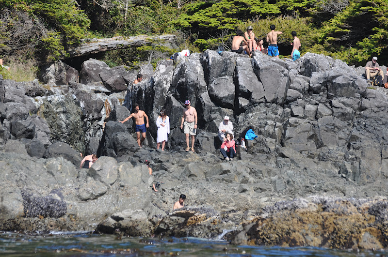


 Hot Spring Cove is a very well protected long cove. I ended anchoring close to the head of it, which is about a half mile from the main park on the south side. The north side has a small Indian village. The park is famous for it's geothermal spring with a strong and VERY HOT waterfall which lies very close to the entrance to the bay. The day I arrived, I took the dinghy to the entrance and took some pics of a dozen or so tourists lazing on the rocks after a good hot soak. During the summer, there are a lot of tour boats that take tourists from Tofino out to this place, and it can get really crowded. There's not a lot of room in the series of rock pools positioned to receive the hot water that pushes through it. I decided to try it first thing in the morning. So to the wharf, then walking west about a mile of boardwalk, many of the boards carved with boat names, apparently a long tradition of boaters. I got there with the first load of tourists, most of them young (like in their 20's). Ho boy! As I was the first to get in, I slowly but surely migrated to the very end of the series of pools, while the place started to fill up. I had a very lovely conversation with a young German woman who lives in New Zealand. I asked her what New Zealand is like, and she said it's very much like here. Well gee, I guess I don't need to visit New Zealand after all!

 After two nights of Ucluelet, I left to go to my jumping off spot to enter the Juan De Fuca straits. Diving into Barclay Sound and the "Broken Group" of islands was interesting - it wasn't as crowded as the San Juan Islands, but it had a lot more boats than I normally saw in Vancouver Island. There is a ton of great anchorages to be had in all of the islands there. I could have spent at least a couple of weeks visiting each anchorage. But instead I stopped by for lunch at a place called Joe's Bay Anchorage, which was a really nice spot to kayak (there were at least 3 separate kayak tours going on - pretty busy). It looked like I was the only one anchored there, although there was a number of yachts going through and checking it out. I ended up staying the night at Dodger Channel, where I spent the evening paddling the paddle board to shore and walking around enjoying the solitude. Only one other small fishing boat anchored that night.


 The next morning, the Osprey took advantage of a light southerly to get around Brooks Peninsula heading north, and Blue Bossa headed south to Scow Bay, a dip in a series of islands called the Bunsby Islands. I had the Scow Bay all to myself, so the first thing I did was launch my kayak (this time in just my trunks and a lifejacket, it was so warm - what a gift!) and explored the inner recesses of a big lagoon, as well as crossing Gay Passage to explore another island (see green route on Bunsby Island chart). Up in the lagoon, I spied a ton of eagles, all sitting there looking regal and majestically swapping branches in the surrounding forest. I also saw a lot of sea otters, which are beginning to grow in larger numbers. The last time I saw sea otters was on Prince of Wales Island in Alaska. It was good to see them again. They're just so darn cute.

 We continued heading south, stopping by to scan out Barter Cove in the Mission Group of Islands, in case we had to anchor their that night, then continued east to Walter's Cove, which lies tucked in Walter Island. Walter's cove is a larger than normal, bustling and pleasant settlement of private houses and sports fishing lodges, filled to the brim with excited sports fishermen (oddly enough). The dock that I tied up to was free (how about that?), and you could get around by way of a series of trails and boardwalks. A clearly marked trail lead me to the Walter Island beach where there were a bunch of driftwood (if in the water, they would be called deadheads) and some HUGE spruce trees. They had a little general store that carried more food products than I saw at Winter Harbour or Coal Harbour, and the lady there was very pleasant.


 The main reason that I was here was to go to the Gwaii Haanas Park Center to get my permit to visit some of the park that is South Moresby. I did that next day, taking a taxi to Skidegate and the park center, where I spent a couple of hours going through the Haida culture and some of the do's and don'ts associated with the park and visiting yachts, introducing the concept of the Watchmen, who are the guides that stay in selected areas in the park and show tourists about the culture and highlights of their little fiefdom. As well, it gave a history of the Haida people taking control of their land in 1983, protesting mightily against the forest companies of clear-cutting their land. I guess their protesting caused enough of an uproar from the rest of Canada, that the government gave almost all of Moresby Island to the Indians as an ecological park and source of education of the Haida culture.
 Once we got around Cumshewa Head, we weaved in and out of various shoals at the entrance of Cumshewa Inlet. The entrance was low lands, but towards the middle of Moresby Island, you could see high snowy peaks inland. Eventually we anchored in Gordon Cove, which was very beautiful, blowing strong out the SE, sharing the cove with one other sailboat, with no sign of life on board.


 A word about his customers - they were two Canadian couples in their 50s who travel all around the world. They live in Edmonton in midwest Canada (flat), and they are the most friendliest and extroverted people I have ever met - gung-ho and enthusiastic on just about everything. They and I went for a tour with James as the guide. James is an articulate and well informed young Haida who gave us absolutely fascinating details about how the cabins were built, the significance of the deteriorating family totem poles and what they stood for, how the culture of family and society was so different than what we're used to and lots of other things. Everything except the totem poles were covered with moss, the village was nice and clear, the trees around it kept the south winds from blowing there. It was all very peaceful.

